Dorian to Strengthen Through Labor Day Weekend, Make US Landfall as Major Hurricane
August 30, 2019
Forecasters are warning of potentially devastating winds, storm surge and heavy rain.
Via accuweather.com:
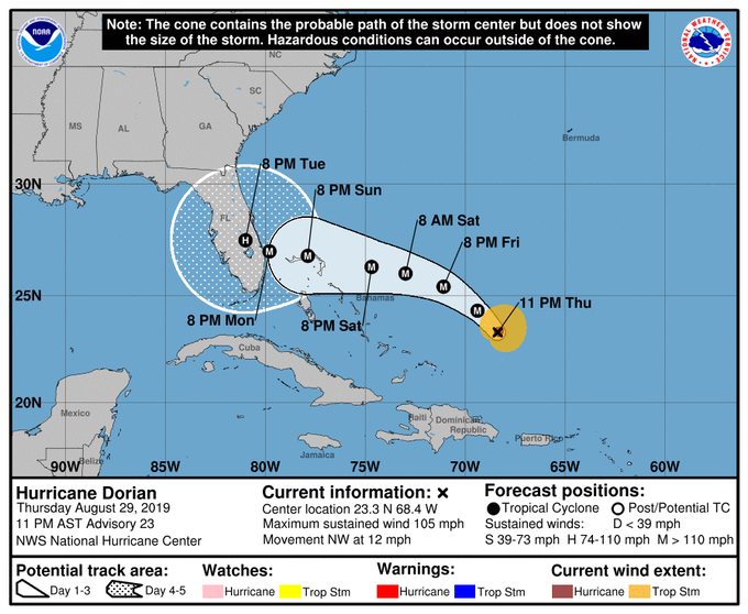
Probable path of Hurricane Dorian. NOAA
While Dorian slowly grew in size, becoming a Category 2 storm late Thursday over the warm waters of the Atlantic, interests in the Bahamas and U.S. continued to intensify preparations ahead of the storm's expected landfall as a major hurricane as forecasters warned of potentially devastating winds, storm surge and heavy rain.
The National Hurricane Center said during its 8 a.m. Friday advisory that Dorian's maximum sustained winds increased to 110 mph. Dorian, located about 255 miles east-northeast of the southeastern Bahamas, was moving northwest at 12 mph early Friday morning. A hurricane watch has been issued for the northwestern Bahamas.
As Dorian, the second hurricane of the Atlantic season, tracks north of the Bahamas later this week, it is expected to reach Category 4 hurricane strength before approaching the southeastern United States coast.

Hurricane Dorian churning closer to the Bahamas early Friday morning. NOAA
A major hurricane has the strength of a Category 3 or greater. A Category 4 hurricane has maximum sustained winds of at least 130 mph.
"The strengthening to a major hurricane is projected to occur while Dorian makes a more westward turn toward the northern Bahamas this weekend," according to AccuWeather Senior Meteorologist Alex Sosnowski.
"With Dorian forecast to pass over the extremely warm water of the Gulf Stream, where cooled, up welled water is rapidly replaced by more warm water, you have to be concerned that a Category 5 storm is on the table before reaching the U.S. coast," Sosnowski said.
A Category 5 hurricane has maximum sustained winds of at least 157 mph.
Recall that Hurricane Andrew, from August 1992 experienced rapid strengthening over the Gulf Stream prior to making landfall in South Florida. Andrew reached Category 5 status prior to making landfall.
The storm made a shift to the north on Wednesday causing its center to regenerate northeast of Puerto Rico and putting forecasters on alert for development of the Atlantic's first major hurricane of the 2019 season.
On Wednesday, Florida Gov. Ron DeSantis declared a state of emergency to give officials enough time to prepare for the storm and urged all Floridians on the state's east coast to "have seven days of supplies, prepare their homes and follow the track closely." Georgia followed suit on Thursday, declaring a state of emergency in 12 counties.
President Donald Trump has canceled an upcoming trip to Europe due to the impending hurricane.
"To ensure that all resources of the federal government are focused on the storm, I have decided to send Vice President Mike Pence to Poland this weekend in my place. It's ... very important for me to be here. This storm looks like it could be a very, very big one indeed," he said at a Rose Garden gathering to establish the U.S. Space Command.
The hurricane brought waves of heavy rain to Puerto Rico and parts of the U.S. and British Virgin Islands on Wednesday after it battered portions of the Lesser Antilles on Tuesday.
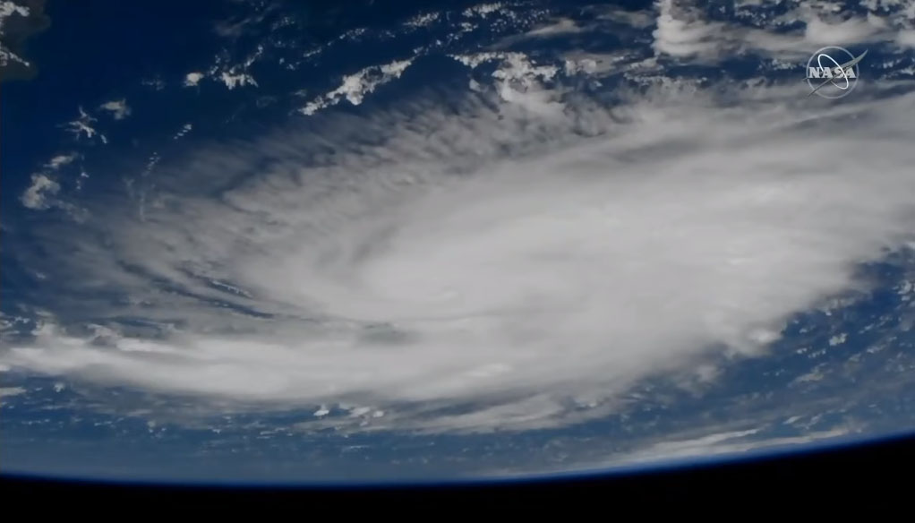
Hurricane Dorian northwest of Puerto Rico from the International Space Station. NASA
AccuWeather meteorologists are forecasting Dorian to intensify into a major hurricane before making landfall as a Category 4 hurricane.
The longer the amount of time Dorian spends over the warm, open waters of the Atlantic, away from major land areas, the greater the chance of significant strengthening.
Cruise and shipping interests from Florida to the waters just north and east of the Bahamas should prepare for hurricane conditions with mountainous seas and high winds.
Some of the far northern islands of the Bahamas will be significantly impacted while the majority of the others will get barely a breeze and a little rain.
"People on Abaco and Grand Bahama should prepare for major hurricane conditions to spread westward over the islands spanning Saturday night and Sunday," Sosnowski said.
"While the exact track of Dorian will determine how severe conditions get on these two major islands in the chain, Cornishtown, Bahamas, near the northernmost point on Abaco could be a hard-hit area," he added.
With several days over the open waters of the Atlantic still to go, the exact track of Dorian for the weekend and beyond is not set in stone.
As a precaution, officials have moved this Saturday's Florida State/Boise State football game from Jacksonville, Florida, to Tallahassee, Florida, at noon the same day.
"A very small fluctuation in the overall weather pattern will have a large influence in where Dorian ultimately tracks and how it impacts the continental U.S.," said AccuWeather Senior Meteorologist Adam Douty.
"If Dorian does slow and turn to the north, impacts in the Carolinas would be much more significant while Florida would be spared from major damage," Douty added.
At this time, AccuWeather believes a landfall over the middle of the Atlantic coast of Florida is most likely.
Now is the time to make sure you have a preparedness plan. Visit AccuWeather Ready for more information on how to be prepared for hurricane season.
"Some things people can do is to stock up on non-perishable items that don't have to be heated prior to eating, such as some canned goods, cereals, etc." Sosnowski said.
- Blue Monster Prep